Balloon mapping workshop
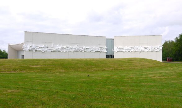
6000km / Exhibition / WorkshopAt Basurama we were invited to participate in the 7 000 000 000 art exhibition curated by arlandismarroqui in the EACC (Espai d’art contemporani de Castelló), and we develop a project to fit the exhibition and our purposes: we wanted to start a local chapter of balloon&kite mappers in Spain, using Public Lab tools, and awake the inactive Public Lab mail list in Spanish. To fulfil our goals we organized a 3 day workshop (January 31st – february 2nd 2014) with local groups to produce 3 local maps.
It was a great time in Castellón. We were able to show how to do balloon mapping to a wide range of people (activists, photographers, mappers) and start a small community of users, let’s see how it develops.
You can check the website with maps and photos of the “Defiende el territorio desde el aire” project (in Spainsh).
Our attempt and results
1. Preproduction
We bought 2 balloon mapping kits (with and without kites) and 2 extra balloons from the Public Lab store. We discovered a week before the workshop that the packages was held in customs, we had to pay taxes (74€).
We bought 2 compact cameras: the Canon Powershot a1300 and a1400 (165€) and 16GB SD cards and rechargeable batteries.
We bought the helium and transported it in a big rented van that could fit the balloon when inflated, so to avoid inflating and deinflating it.
2. Contact local groups
We made a public call and emailed/phone called different local environmental groups and citizens. We asked them which places they would be interested to map and made collaboratively a list with potential locations to map. We wanted to support local struggles that were already engaged with the defense of the territory. Castellón region is a good example in Spain to show the destruction the real estate bubble caused.
We got some groups engaged in the project in Valencia and Castellón:
- In El Saler village, a local organization was fighting to revert the construction of road into a street to recover their historic access to their harbour lake. Map available.
- In Castellón, a local ecologist group was interested in having a look to what was happening in an industrial area (El Serrallo) in the harbour that contained a BP refinery, an incinerator plant for dangerous substances, and two thermal plants. Map available.
- A new residential area was going to be built, but it got stopped and left a “broken” mountain at the north of La Vall d’Uixó. Map available. The local group of Ecologistes en Acció is planning to use the photos for their mobilizations.
3. The workshop: theory and practice
We split the workshop in parts:
Theory (indoors):
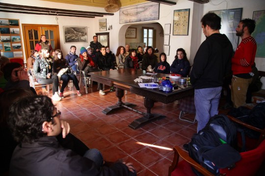
Friday afternoon we organized a 3 hour workshop on:
- introduction to Basurama, Public Lab and 6000km project.
- digital cartographies (Open Street Map, GPS traces, layers)
- aerial photography (passenger pigeon, pole photography, and ballon mapping)
- a mapknitter session with existing photos from mapmill (Tidmarsh Farm)
- free licensing theory, open research
- discussion on which locations to map. Local groups told what was interesting for them.
Around 20 people showed up: ecologists, artists and local activists. Ecologistes en Acció del País Valencià y Molts Mons.
Practice (outdoors):
On Saturday (10am until sunset at 6pm) we made a session in Castellón outskirts with all the participants from Friday, We taught how to build a rig and inflate a balloon. We made our first flights in the vicinity of the refinery, El Serrallo. We only could get the border of such a huge industrial area, wind didn’t help
After a good paella lunch we continued mapping in Moncofar, in one of those places where streets have been built, but no buildigns are around. We got many motion blurred pictures (we had wrongly set the mode of the camera to aperture mode), not enought to build a good map.
After every flight we downloaded the images to our laptop and to the laptop of one of the participants. For next time we have to remember to tell participants to bring their own laptops, usb or hard drives to bring the images home with them. Later on it is much more complicated to transfer so many images (6200 images that day, 6 flights in 2 locations, 15.3GB). There was not enough wind to fly kites.
Results were great but we were concerned with the lack of sharpness of the images, check the thread about this in the Grassroots Mapping list. Cheap Canon powershot a1400 and a1300 are great, but not the best quality. The final maps looked good, though!
In some of the images, because of the strong wind (or other deffect), the camera moved inside the 5 liter water PET Bottle with the Rubber Band Rig, and we got some or the corners of the images with the bottle. we tried in the next flights to fix the camera better.
Introduction to the workshop at Casa de la Demaná, in El Saler (Valencia).
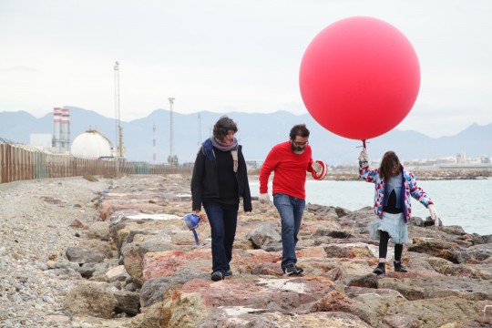
On Sunday we travelled 1 hour south, to the outskirts of Valencia city, to El Saler to map the CV-500 road that separated since decades villagers from their lake. After a quick introduction (a short version of the Friday workshop + how to build a rig) in the indoors space of the local association we started mapping. We made a boat trip to map the road and the lake as well.
The road CV-500 that separates EL Saler villager from their harbour’s lake.
The regional association of associations Avinença had announce the workshop and many people (around 50) came to the workshop. It was difficult to manage such a big group. Our plan was to use the 2 kits and split the group in two, but one of the cameras was missing! It appeared later inside a bag… keep your cameras close!
After a brief meal in a bar we tried to find a place were to show the photos and make a quick demonstration with mapknitter. (5 fligths in one location, 5291 photos, 14.7GB).
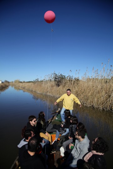
Mapping from a boat going to l’Albufera
4. Postproduction
After 3 days of intense flying and workshopping we still had to select and knit and print the maps for the exhibition. We made an extra flight in La Vall d’Uixó to be sure we had good images!
Though every night after flying we had ordered the images, we still had to select the good ones and decide which ones could be good enough to build a map. We wanted to make this process collaboratively with local groups, but due to the short time we had left we had to do it on our own (we had to come leave Castellón) Rubén and me, the Basurama team at Castellón.
After a long mapknitting session until late that night we started exporting the three maps. We had some problems with the tool crashing, better export them one at a time.
Next morning we continue fixing some errors in the maps and exporting. Later on we used Inkscape to prepare the maps for printing: add scale, north and explanatory text. Ready for print in 1.2×1.2m paper and hang onto the wall.
For next time it would be better to to some extra time to make a mapknitting session with the participants, otherwise they don’t get a sense of the whole process (though we have explained it) and maps appear magically finished!
5. Exhibition
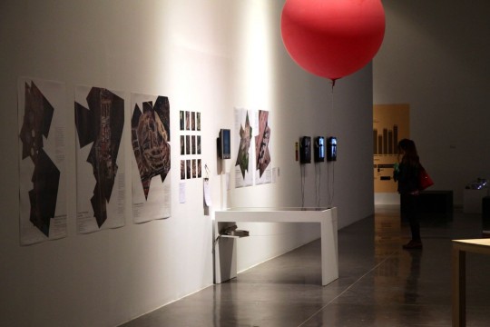
The results of the workshop at EACC in the 7 000 000 000 exhibition
The collective exhibition was opening on Friday night, the day the workshop was starting. We displayed previous related maps and a note on the wall saying that we would print the results of the workshop.
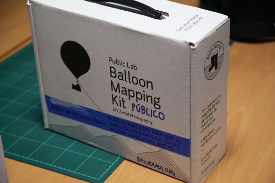
Public Lab balloon Mapping kit at the exhibition
Our section displayed:
- Previous maps: Saugus Landfill (MA, USA), Ruins of PAU ensanche Vallecas (Madrid, Spain).
- Balloon and kite mapping kit
- Google maps and Bing aerial photographs of the locations local groups wanted to map.
- List of the locations local groups wanted to map
- Screen with photos of the workshop
- Maps, results of the workshop
- Balloon (while the helium inside lasted)
Maps
Polígono industrial El Serrallo #
Castellón de la Plana. 1 febrero 2014.
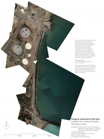
In Castellón, a local ecologist group was interested in having a look to what was happening in an industrial area (El Serrallo) in the harbour that contained a BP refinery, an incinerator plant for dangerous substances, and two thermal plants. Map available.
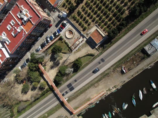
Carretera CV-500 a su paso por El Saler
Valencia, España. 2 de febrero 2014
-
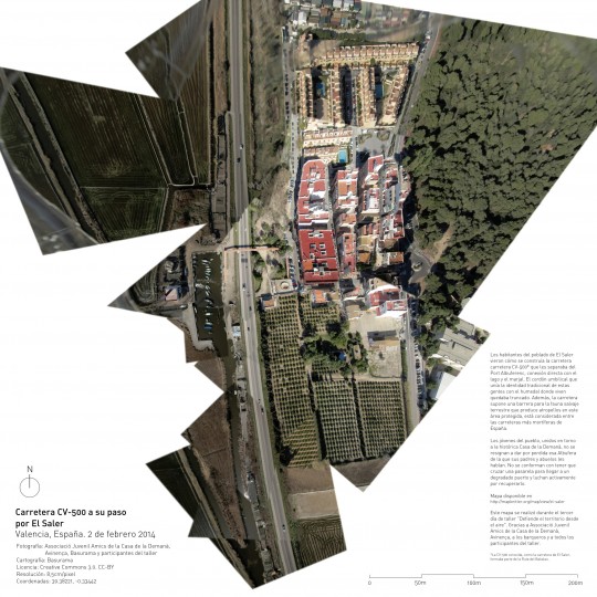
El Saler and the CV-500 road
In El Saler village, a local organization was fighting to revert the construction of road into a street to recover their historic access to their harbour lake. Map available.
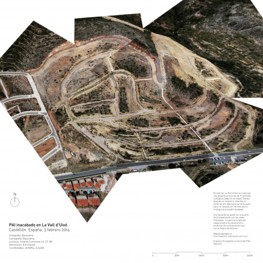
PAI inacabado en La Vall d’Uixó #
Castellón. España. 3 febrero 2014
A new residential area was going to be built, but it got stopped and left a “broken” mountain at the north of La Vall d’Uixó. Map available. The local group of Ecologistes en Acció is planning to use the photos for their mobilizations.
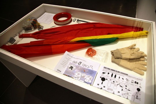
The public Public Lab balloon mapping kit
One of the main goals was to build a local community of balloon mappers. One kit with a camera and a bottle rig remained in the exhibition space, and the other ready for the participants to use during the 3 months that the exhibition lasts, until April 27th 2014. Many people got excited during the workshop, but then we know that it is not easy, even when you have the kit, to organize a flight. Let’s see how it works.
The project has participated inen
The propject has taken part in different forum and exhibitions:
- The project took part in the 7 000 000 000 art exhibition curated by arlandismarroqui in the EACC (Espai d’art contemporani de Castelló) from January 31 to April 27 2014.
- We were invited to participate in the “Emerging ICT for Citizens’ Veillance: Theoretical and Practical Insights” workshop organized by the Institute for the Protection and Security of the Citizen of the Joint Research Centre of the European Commission (March 20-21 2014. Ispra, Italy). Slides of the presentation are available.
- Photos of the project were included in the Big Bang Data exhibition at CCCB to illustrate uses of the Public Lab Balloon Mapping Kit. (Barcelona, May 9 – October 26 2014).
- The project got included in the video documentary No Comment by Julian Barón that was presented in PhotoEspaña 2014.
Thanks to / Collaborators
Public Lab community for helping us think and organize this set of activities
Locations and research: Avinença, Ecologistes en Acció del País Valencià, Molts Mons and Casal Popular de Castelló
Photos: Lot and Lucía helped with the documentation.
This text is partially crossposted at PublicLab.org.